Commercial & Municipal
Land Clearing
HOAs, developers, utility companies, and municipalities need land clearing that scales. We handle multi-parcel projects with satellite-based quoting, volume pricing, and the Cat equipment to back it up.
HOA Common Area Maintenance
Homeowner associations manage walking trails, retention pond perimeters, buffer zones between subdivisions, and common-area green spaces that require clearing beyond what a standard landscape crew handles. When brush and saplings invade these areas, the standard mower cannot keep up.
We work with HOA property managers on both one-time reclamation projects and annual maintenance contracts. A typical HOA engagement starts with forestry mulching to restore overgrown common areas to a maintained state, then transitions to annual brush hogging to keep them open. Walking trails through wooded HOA land get the same treatment — mulched to create the initial path, then maintained annually to keep them clear.
Retention pond perimeters are a common HOA pain point. County stormwater regulations require maintained access around retention basins, but these areas are usually the first to be neglected because they are at the back of the subdivision where nobody sees them until an inspector does. We clear the perimeter back to compliance standards and maintain it on schedule.
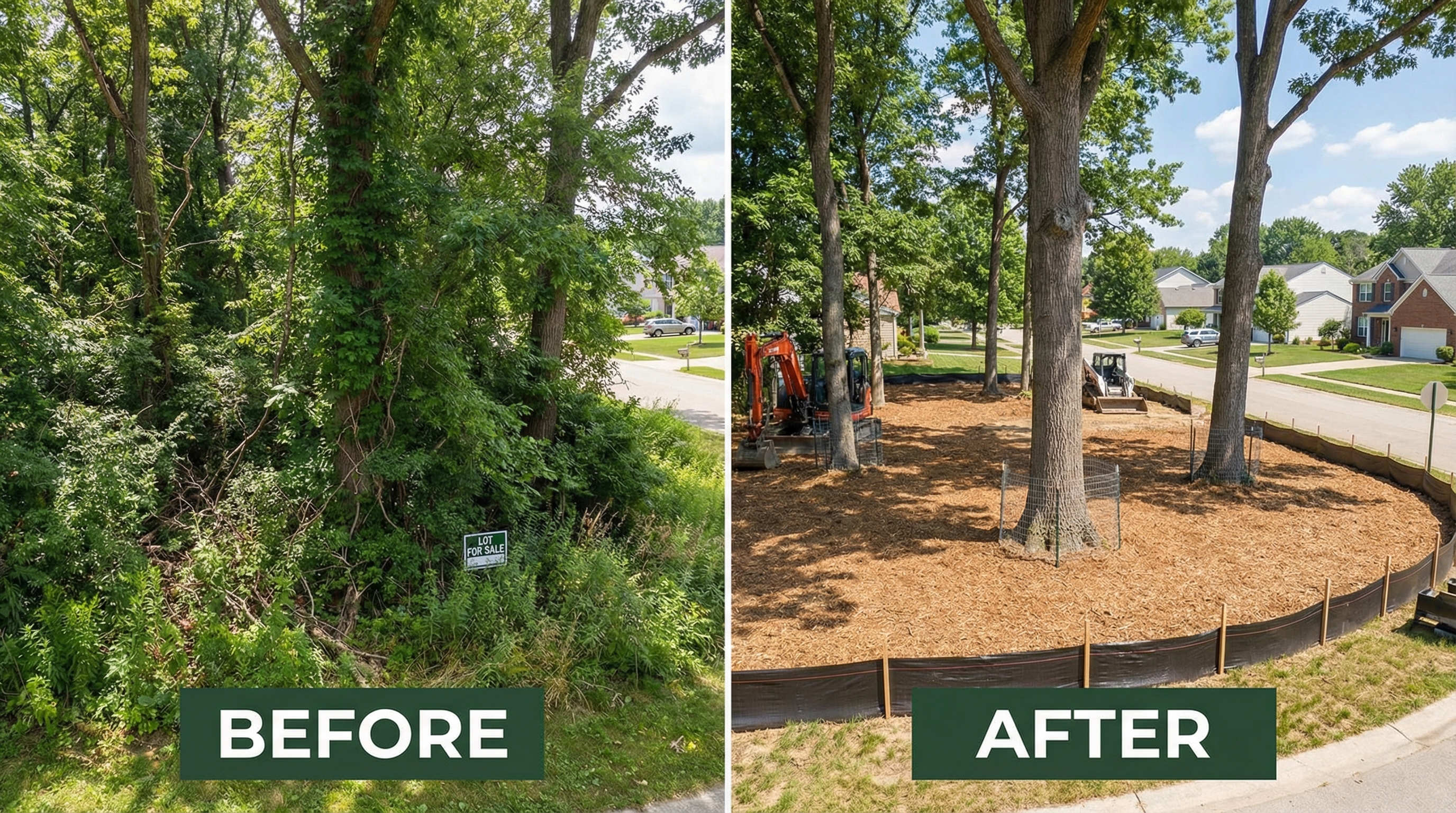
Developer Lot Clearing for Subdivisions
Residential subdivision developers clearing 5, 10, or 20 lots at once get volume pricing that makes mulching competitive with dozer clearing — without the topsoil loss, erosion problems, and hauling costs that come with bulldozing.
For multi-lot projects, we assess the entire development parcel from satellite imagery, classify brush density by lot, and provide a per-lot fixed price for the full project. Each lot gets cleared to the builder's specifications — building footprint plus work zone, driveway corridor, utility paths, and selective preservation of mature trees the developer wants to keep as selling features.
Commercial parcel clearing for retail, industrial, or mixed-use development follows the same process at larger scale. Access roads, staging areas, and perimeter buffers are all included in the scope assessment.
Utility Right-of-Way Vegetation Management
Power line corridors, pipeline easements, and telecom ROWs require periodic vegetation management to maintain clearance standards and prevent outages. These are linear clearing projects — narrow corridors that may extend for thousands of feet across varied terrain.
Forestry mulching is well-suited to ROW work because the Cat 275 XE on rubber tracks causes minimal ground disturbance in the easement. This matters on pipeline corridors where soil compaction or disruption could affect cathodic protection or pipe coating integrity. The mulch layer left behind stabilizes the cleared corridor and reduces erosion between maintenance cycles.
For utility clients with recurring annual or biannual maintenance schedules, we offer contracted rates that lock in pricing across multiple maintenance cycles. This simplifies budgeting for vegetation management programs that cover dozens of miles of corridor.
Municipal Land Management
Townships, cities, and county parks departments manage public land that needs periodic clearing — park trails, road shoulder vegetation, public greenways, and abandoned parcels that become nuisance properties when brush takes over.
Road shoulder clearing keeps sight lines open at intersections and curves where overgrown brush creates blind spots for drivers. Park trail maintenance keeps walking and biking paths accessible and safe. Abandoned lot clearing reduces fire risk and eliminates harborage for invasive species that spread to neighboring properties.
We work within municipal procurement processes and can provide W-9, COI, and any required documentation for vendor registration. For recurring maintenance contracts, we structure invoicing on net-30 terms aligned with municipal payment cycles.
Satellite Quoting for Portfolio Assessment
For commercial clients managing multiple properties or large parcels, our satellite-based quoting process delivers accurate estimates without scheduling site visits for every location. Send us a list of addresses or parcel IDs and we assess brush density, acreage, terrain, and access from satellite imagery.
You receive a per-parcel fixed price with brush density classification, estimated timeline, and any special access or terrain considerations. For complex sites that satellite imagery cannot fully assess, we schedule a brief on-site review before finalizing the quote.
Commercial Project?
Get Volume Pricing.
Send us your property list or parcel IDs. We'll assess from satellite and deliver per-parcel fixed pricing within 48 hours.